


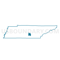
07 Forrest Mill Church of Christ Activity Center Voting District, Coffee County, Tennessee
About
Outline

Summary
| Unique Area Identifier | 668178 |
| Name | 07 Forrest Mill Church of Christ Activity Center Voting District |
| County | Coffee County |
| State | Tennessee |
| Area (square miles) | 42.91 |
| Land Area (square miles) | 42.86 |
| Water Area (square miles) | 0.05 |
| % of Land Area | 99.87 |
| % of Water Area | 0.13 |
| Latitude of the Internal Point | 35.49991020 |
| Longtitude of the Internal Point | -85.97016050 |
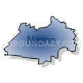
Maps


Graphs
Select a template below for downloading or customizing gragh for 07 Forrest Mill Church of Christ Activity Center Voting District, Coffee County, Tennessee


Neighbors
Neighoring Voting District (by Name) Neighboring Voting District on the Map
- 04 First Baptist Church Voting District, Coffee County, TN
- 05 Hillsboro Community Center Voting District, Coffee County, TN
- 06 Tennessee Vocational Center Voting District, Coffee County, TN
- 08 New Union Fire Hall Voting District, Coffee County, TN
- 09-1 Morrison Ruritan Club Voting District, Warren County, TN
- 09-2 Summitville Comm Center Voting District, Coffee County, TN
- 09-2 Viola Valley Comm. Center Voting District, Warren County, TN
- Hubbard's Cove Voting District, Grundy County, TN
Top 10 Neighboring County Subdivision (by Population) Neighboring County Subdivision on the Map
- District 1, Grundy County, TN (4,573)
- District 9, Warren County, TN (3,552)
- District 8, Coffee County, TN (2,897)
- District 9, Coffee County, TN (2,683)
- District 6, Coffee County, TN (2,656)
- District 7, Coffee County, TN (2,602)
- District 5, Coffee County, TN (2,522)
- District 4, Coffee County, TN (2,349)
Top 10 Neighboring Place (by Population) Neighboring Place on the Map
Top 10 Neighboring Elementary School District (by Population) Neighboring Elementary School District on the Map
Top 10 Neighboring Secondary School District (by Population) Neighboring Secondary School District on the Map
Top 10 Neighboring Unified School District (by Population) Neighboring Unified School District on the Map
- Warren County School District, TN (39,839)
- Coffee County School District, TN (25,438)
- Grundy County School District, TN (13,703)
Top 10 Neighboring State Legislative District Lower Chamber (by Population) Neighboring State Legislative District Lower Chamber on the Map
Top 10 Neighboring State Legislative District Upper Chamber (by Population) Neighboring State Legislative District Upper Chamber on the Map
Top 10 Neighboring 111th Congressional District (by Population) Neighboring 111th Congressional District on the Map
Top 10 Neighboring Census Tract (by Population) Neighboring Census Tract on the Map
- Census Tract 9308, Warren County, TN (6,091)
- Census Tract 9707, Coffee County, TN (4,290)
- Census Tract 9706, Coffee County, TN (4,005)
- Census Tract 9701, Coffee County, TN (3,842)
- Census Tract 9550, Grundy County, TN (2,770)